 |
| Upper Cataract Falls |
A rough year is over, but at least we have water! Holy cow. Down from "exceptional drought" to only "severe drought"? Heck, I might even wash my car.
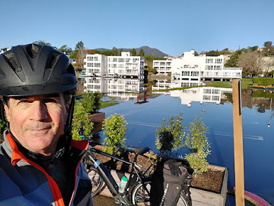
I wanted to bike up to Mt. Tam this morning to check on my trail cams, and also to close out the year doing something fun on a sunny day, although it was a little brisk out there. The National Weather Service showed Mill Valley at 34 degrees just before I left. Thankfully the day warmed up quickly, and it was a mellow ride out of the city and across the Golden Gate, all the way to the end of Sausalito. And then I saw something I'd never seen before:
 |
| Flooded Bike Route |
It got better! At the other end of the ramp, the exit to Mill Valley was closed. Completely flooded. Even cars were blocked from getting through. Did that deter the peloton? Not even for a minute. I had jumped on my e-bike right after taking the photo above and was following the pack. All of a sudden we're riding along on the edge of the freeway and going up and over the bridge over Richardson Bay, finally getting off at the first Strawberry exit.
With all my stopping for flood-selfies (getting Mt. Tam in the background) I lost the bike group, but I just followed Hamilton Drive up to Bayfront Park, then picked up Camino Alto to Miller going past Tam High until it turns into Almonte Boulevard. Thankfully Tam Junction wasn't flooded, so I was soon heading up Shoreline Highway. A car would have to take Hamilton to Roque Moraes Drive, then left on E. Blithedale to Camino Alto, then maybe take the short-cut of R. on Miller then L. on Edgewood and up Sequoia Valley to Panoramic. If we decide to go for a hike tomorrow morning, I suspect that's the route we'll take. Gonna be king tides all weekend, thanks to the New Year's New Moon!
* * *


