I forgot my snow shots weren't already on the blog (except this one), so I thought I'd post them in light of the possibility of getting some new snow this week. I doubt anything like this 2011 snowfall is in the cards, but you never know.
The Great Highway had an unscheduled automobile closure today, courtesy of Mother Nature.
Two phone snaps from the edge of the dune.
I avoided this bike/pedestrian path yesterday because the wind was even stronger, making this stretch look like it was being sand-blasted. Looking back the other way, a car is taking a detour through the Beach Chalet's parking lot because there is deep sand accumulated on the Great Highway, and not just here but in many spots along the front of Golden Gate Park.
I was going to head back up through the park when I noticed huge waves crashing into Seal Rocks: guano cleaning, courtesy of Pacific Power Wash. I was also amazed to see a group of sturdy young people doing a beach clean-up. They should have had some news media down there. I was not surprised when their supervisors called them in shortly after I packed my camera to get the heck out of that cold wind.
Luckily, this tree (one of several newly fallen trees since yesterday in Golden Gate Park) broke in two in just the right place. :)
I went down to the beach yesterday, and I'm still finding sand in my ears.
Early morning started off innocently enough, with just the usual breeze, but by mid-morning the forecast winds began to arrive. Toppled garbage cans lined my walking route, and I heard the wind slam a door shut on 16th Avenue, followed by the sound of shattering glass.
Once I got home from my morning walk I wasn't so sure I even wanted to go for my usual bike ride. But I did want to experience the powerful winds. And when I remembered the hand-held anemometer I'd stowed away in a knick-knack drawer I knew I had to take it for a ride to the beach. When I got there, I struggled against the headwind despite being on an ebike. I sure was glad I'd ridden up to Mt. Tam on Monday instead of Tuesday.
I probably wouldn't have stopped on my way to Mt. Tam yesterday if I hadn't spotted the American Avocets foraging along the shore of Richardson Bay near Coyote Creek. The Black-Necked Stilts are still around, but seeing avocets in this area was a new sighting for me. They were unafraid of my presence and fed just a few feet away, scything their bills back and forth but not snagging anything I could see. Well-camouflaged Willets foraged for critters in the saltgrass, moving about on foot while whistling Wigeons nibbled on plants from the water.
The holiday auto traffic was fairly heavy on Panoramic Highway, but I had decided not to wait to go up today because of the forecast of heavy winds. Yesterday was a gorgeous day for a bike ride. On reaching Mt. Tam my odometer showed I was about 50 miles away from reaching 10,000 miles. Next month I'll have had the ebike four years. Estimates for battery life are all over the place, but mine still seem to be fine.
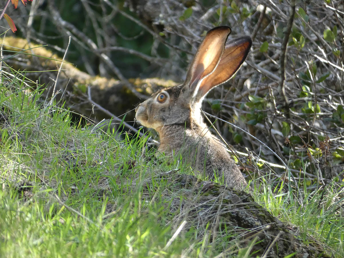
On the hike up to the cams I spotted the biggest jackrabbit I've ever seen. It was a sprightly hare despite its size and galloped off in the direction of my cams, then finally zoomed up the hill and out of sight after allowing me a quick photo.
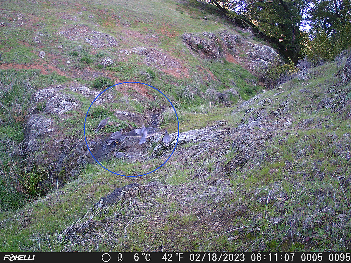
When I reached the cams I was excited to find a crime scene -- Band-Tailed Pigeon feathers in a pile -- next to the little creek. The cameras appear to have caught an attack from maybe a Cooper's Hawk, but it happened too fast, and the image is too weak, to be sure. The other interesting capture was an animal I can't identify. If we had Pikas, I might have guessed that's what it was. If you have any ideas, drop me an email (jwallphoto at either gmail or yahoo).
American Avocets & Black-Necked Stilt
American Avocets on Richardson Bay
Feeding Avocet Showing Curved Beak
Willet in the Pickleweed and Saltgrass
Male Wigeons on Coyote Creek
Jumbo Jackrabbit
Crime Scene
Band-Tailed Pigeons Drinking from Creek @ 8:11:07 a.m.
Fleeing Pigeons & Crime Scene @ 8:11:45 a..m.
100% View of Blue-Circled Bird (Is it a raptor or just another pigeon?)
Reaching the steps at 14th Avenue and Mount on my walk Friday morning, I could see a corduroy ocean. Countless swells were marching in lines toward the beach, and the wind was blowing offshore. Probably going to be good surfing conditions, but I was just far enough from home that I didn't want to turn back and get my camera.
I could see the ocean pretty much the whole way as I walked down Noriega Street, but when I finally got to the beach I knew I was going to have to come back with a camera. I watched for a little while, then walked back home and returned on my bike with the FZ80.
Steps at 14th & Mount
Zoomed In View With Lines of Swells
Bottom Turn
Ship Spotting & Surf Photography (Container Ship President Kennedy; the APL is for American President Lines)
Frame Capture from Last Clip in Video Below
Guy Paddling Out Gets Sucked Over the Falls (Frame capture from same clip; it happens almost too fast to catch in the video)
Since I placed my trail cams in a new location last week, I wanted to get up there to see how they were doing. Sometimes a spot looks like it has potential but turns out to have one of the worst kinds of problems: too many activations caused by vegetation blowing in the wind. Another time I had a location that had zero activations in a week -- no animals whatsoever, not even a bird or butterfly. The worst though, was a location that captured nothing but dragonflies and thousands of wind-activations.
Usually a wind-activation is the result of something in front of the camera, anything from a plant you didn't notice (or that blew into the frame after setting up the cam), to bushes that seemed innocuous when you set up the cam on a day with little or no wind, but which tossed like crazy later on and set off a couple thousand "empty" frames.
When I got my SD cards home and saw that one cam had 591 captures, and the other had 2,118, I knew right off that I had a wind problem -- although neither involved movement in front of the camera. Instead, both were caused by movement of the tree I'd mounted the cams on. Although it was somewhat tedious to sort through all those frames, I at least got some decent captures (video below).
Because of recent issues with my bike tires (my new pump and innertubes have arrived, but my new tires won't come till Monday) I didn't feel comfortable riding all the way to Mt. Tam, which is how I usually prefer to get up there for cam-checks. Since I was driving the car I figured I might as well bring my DSLR and poke around the mountain a little bit. My first stop was to check out a large patch of calla lilies, but only a few were in bloom. I continued out that trail a little bit in the hope of spotting a hunting bobcat, but no luck there.
I continued up to Rock Spring and hiked down the Cataract Trail a ways to look for calypso orchids and fetid adder's tongue. I didn't see orchids in any of the usual locations, but I was glad to see that the fetid adder's tongue was still in bloom. It's still early for the orchids, which often bloom into April. In the past I've found them as early as February 20. That was 2016, and this year is no 2016, flowerwise. The forest seemed quite dry.